
Coulsdon
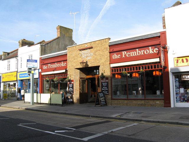
The town centre itself, and the reference point every distance on this page is measured from.
Browse the CR5 postcode directoryArea guide
Where suburban London begins to loosen into chalk hills and open country, Coulsdon occupies a distinctive place between city and Surrey. Brighton Road forms its busy town-centre spine, Victorian and Edwardian streets climb away from the shops, and Farthing Downs opens beyond the rooftops. Old Coulsdon preserves the area's older village heart, while the railway town grew around Coulsdon Town and Coulsdon South stations. Together, these different sides give CR5 a character that is unmistakably its own.

Dr Neil Clifton · CC BY-SA 2.0 · Wikimedia Commons
Population (2011)
25,695
Wikidata
Local authority
London Borough of Croydon
Postcode district
CR5
Streets on Door Number
391
CR5
Addresses on Door Number
9,943
CR5
Schools returned
10
current DfE search result
Coulsdon on South London's edge belongs administratively to the London Borough of Croydon, but it still carries the older identity of Surrey, the county it sat in for centuries before London's boundary moved outward to meet it. Old Coulsdon, the original settlement, keeps a village green, a cricket pitch and a medieval church, while the town centre that later took the Coulsdon name grew up around the railway a mile or so to the north-west. The two are easy to confuse by name alone, so this guide treats them as the separate places they are rather than one blended entry.
Coulsdon began as a chalk-valley coaching stop called Smitham Bottom that grew fast once the railway reached it in 1889, taking the name Coulsdon from the older village to its south-east. Today Brighton Road still carries the bulk of the town centre's shops and everyday business, with the surrounding streets given over almost entirely to housing. Its railway stations, Coulsdon Town and Coulsdon South, remain a large part of why the town looks the way it does today: development followed the line as much as it followed the road, and the two stations still mark out the town's two historic halves. Housing across the area today reflects that century of expansion, a mix of periods and styles rather than a single uniform development, running from villa-era terraces near the station out through solid Edwardian avenues to interwar semis and postwar estates further from the centre.
What sets Coulsdon apart from a purely suburban stretch of London is how close open country remains: Farthing Downs and Happy Valley rise within easy reach of the town centre, chalk downland that has never been built on. Streets of Edwardian and interwar housing give way within a few minutes' walk to grassland, scrub and long views south towards the Surrey hills. Green space of this kind rarely makes headlines, but it shapes ordinary life here all the same, from a Sunday walk to the school run.
Older maps and directories knew the town centre by a different name entirely: Smitham Bottom, a name the Post Office formally dropped in favour of Coulsdon in the early twentieth century, much to the annoyance of some residents who preferred the old one. South of the centre, the site of the old Cane Hill Hospital, a sprawling Victorian asylum that once dominated the skyline, has been cleared and rebuilt as new housing, closing one of the area's stranger and more debated chapters.
Coulsdon was an ancient Surrey parish long before London ever reached it. It joined Sanderstead in 1915 to form the Coulsdon and Purley Urban District, and only in 1965 did that district pass into the newly created London Borough of Croydon, ending seven centuries of Surrey administration in a single stroke of the map.


Homes in Coulsdon
Census 2021 figures for Croydon 041C, a statistical area covering part of Coulsdon.
Flats, maisonettes or apartments are the most commonly recorded accommodation type here. About 50.3% of households are owner occupied and 25.8% are privately rented.

Owner occupied 50.3% · Private rented 25.8% · Social rented 14.4% · Shared ownership and other 9.5%
Census 2021 · Croydon 041C · part of Coulsdon. Figures are rounded and cover all households in this Census area, not a boundary for Coulsdon as a whole.
Derived statisticCensus 2021, Office for National Statisticsrecorded 21 March 2021 · checked 21 September 2026
Household counts from Census 2021 tables TS054 (tenure) and TS044 (accommodation type) for this Lower-layer Super Output Area, retrieved from Nomis. Percentages are calculated by Door Number as the count divided by the table total, rounded to one decimal place. These figures describe the surrounding Census area of roughly 1,000–1,200 households and are not a statement about this individual property.
Census 2021 data from the Office for National Statistics, via Nomis. Contains National Statistics data © Crown copyright and database right. Licensed under the Open Government Licence v3.0.
Property market
Recorded sale-price context for the CR5 postcode district, from HM Land Registry Price Paid data served through Resi IQ, not a valuation of any individual property.
Median recorded sale price: 2026 year-to-date, CR5 postcode district
£550,000
Based on 155 qualifying recorded sales.
4% lower than full year 2024 (£558,750 to £535,000).
Recorded transactions, since 1995
15,211
2026 figures are year-to-date, not a complete year.
Roads with recorded sales
328
Most recent recorded sale
24 July 2026
All property types · CR5 postcode district · Resi IQ, from HM Land Registry Price Paid data. Annual figures are the median of recorded sale prices for that year, as supplied by Resi IQ; Door Number does not separately filter or adjust these values.
Recorded sale prices over time
CR5 postcode district, 2019–2026: from £528k to £550k (median recorded sale price, HM Land Registry via Resi IQ); the 2026 figure is year-to-date, not a complete year.
Detached houses (2026 YTD)
£857,500
43 sales · year-to-date
Semi-detached houses (2026 YTD)
£585,000
45 sales · year-to-date
Terraced houses (2026 YTD)
£418,500
22 sales · year-to-date
Flats and maisonettes (2026 YTD)
£278,500
36 sales · year-to-date
Neighbourhoods
Relative to Coulsdon: Clockhouse (NW, about 0.9 miles from Coulsdon); Old Coulsdon (SE, about 1.2 miles from Coulsdon); Woodmansterne (W, about 1.4 miles from Coulsdon); Little Woodcote (NW, about 1.5 miles from Coulsdon); Kenley (E, about 1.5 miles from Coulsdon); Chipstead (SW, about 1.6 miles from Coulsdon); Purley (NE, about 1.6 miles from Coulsdon); Woodcote (N, about 1.8 miles from Coulsdon).
Coulsdon is not one single, uniform place. It shares its postcode district with Old Coulsdon, and the two sides of the area have grown up with genuinely different characters rather than one simply being a suburb of the other. Old Coulsdon, the original settlement, keeps a village green, a cricket pitch and a medieval church, while the town centre that later took the Coulsdon name grew up around the railway a mile or so to the north-west. A search for Coulsdon and a search for its older neighbour can genuinely point to different streets, shops and buildings, not two names for one place. Brighton Road and the streets around it carry the practical, everyday side of the area: shops, transport links and a steady flow of passing traffic, with the surrounding roads given over to housing built up over the last century or so. Much of that residential growth followed the railway rather than any planned scheme: streets near Coulsdon Town and Coulsdon South filled in first, with later estates spreading outward as the twentieth century went on. Walk far enough from either centre and the streets give way to the open chalk of the North Downs at Farthing Downs and Happy Valley, a reminder that this is still the edge of London rather than deep inside it. Further out, Clockhouse, Woodmansterne, Little Woodcote, Kenley, Chipstead, Purley and Woodcote are neighbouring places in their own right, each with its own character, from an old aerodrome to a wooded valley, set out individually below rather than lumped together as one suburb. The diagram below plots each named place by its approximate direction and distance from Coulsdon's centre, giving a quick visual sense of how the area actually fits together. Positions are indicative rather than administrative boundaries, and sharing a postcode district does not make two places the same locality.
The town centre itself, and the reference point every distance on this page is measured from.
Browse the CR5 postcode directory
A named locality south-east of central Coulsdon, about 1.2 miles away. Recorded on OpenStreetMap as a village. Within the CR5 postcode district, alongside Coulsdon.
View Old CoulsdonListed here for orientation only: separate towns with their own postcode districts, not covered by this directory.

Schools and connections
Explore open schools and public-transport access points recorded around Coulsdon, using Department for Education and NaPTAN data.
A mix of school types serve the search area, with options across the phases returned below.
10
schools returned within the current search area
8
Primary
1
Secondary
1
Other phases
Woodcote Primary School
Smitham Primary School
St Aidan's Catholic Primary School
Oasis Academy Byron
Woodcote High School
Beaumont Primary School
Chipstead Valley Primary School
St Nicholas School
New Valley Primary School
Coulsdon CofE Primary School
Department for Education, Get Information about Schools
Official recordGet Information about Schools (DfE)recorded 6 September 2026 · checked 21 September 2026
Open schools within 2000 m of Coulsdon's approximate centre from the Department for Education's Get Information about Schools register (Croydon local authority), ordered by straight-line distance. Phase and age range are the DfE's. No quality, catchment or admissions information is stored: each school links to its live Ofsted report. Results are measured from Coulsdon's approximate centre, not a specific address.
Contains Department for Education data licensed under the Open Government Licence v3.0.
7 rail stations recorded near Coulsdon, plus 40 bus stops.
A list of stations recorded near Coulsdon, not a route map. Order is not a journey sequence.
Recorded transport access points from NaPTAN. Live departure times and current service frequencies are not shown.
Department for Transport, NaPTAN
Official recordNaPTAN (national public transport access nodes)recorded 13 September 2026 · checked 21 September 2026
Active rail stations within 3.5 km and bus stops within 900 m of Coulsdon's approximate centre, from NaPTAN (the Department for Transport's National Public Transport Access Nodes register), ordered by straight-line distance. No journey times or service frequencies are implied. Results are measured from Coulsdon's approximate centre, not a specific address.
Contains NaPTAN data © Crown copyright, licensed under the Open Government Licence v3.0.
How this is measured
Schools come from the Department for Education's Get Information about Schools register; transport access points come from NaPTAN. Results use configured search radii from Coulsdon's reference point, and all distances are straight-line, not school catchments, live timetables or journey-time estimates.
Community and amenities
Beyond the housing and the history, Coulsdon is also the shops, health services and community facilities people actually use day to day. 59 amenities and facilities are mapped below, drawn from OpenStreetMap and not a complete directory.

Community-sourced (discovery)OpenStreetMap contributorschecked 21 September 2026
Counts of amenities mapped within 800 m of Coulsdon's approximate centre by category, from OpenStreetMap, a community-maintained dataset used here for discovery. Coverage is uneven and may be incomplete or out of date. Results are measured from Coulsdon's approximate centre, not a specific address.
© OpenStreetMap contributors, licensed under the Open Database Licence.

Planning and place
Every town keeps changing, and planning applications are usually the first sign of it. Below is recent development activity, flood context and listed heritage recorded near Coulsdon, for a general picture of the area rather than any single property.
Town-level context, not a property-specific flood assessment.
Coulsdon's reference point is not shown within Flood Zone 2 or 3 on the Environment Agency's Flood Map for Planning (rivers and sea only). This map does not cover surface-water or groundwater flooding, so this is not a statement that the area is free of flood risk.
Official recordplanning.data.gov.ukchecked 21 September 2026
The Environment Agency's Flood Map for Planning (Rivers and Sea), Flood Zones 2 and 3, from planning.data.gov.uk, tested against a small area around the coordinates of Coulsdon's approximate centre. This map covers flooding from rivers and the sea only; it does not cover surface-water or groundwater flooding, and is not a property-level flood-risk report. Results are measured from Coulsdon's approximate centre, not a specific address.
Contains public sector information licensed under the Open Government Licence v3.0.
No current Environment Agency flood warning or alert was returned for the area searched around Coulsdon's reference point, at the last check.
Official recordEnvironment Agencychecked 21 September 2026
Flood warnings and alerts in force NOW, and the named flood areas, from the Environment Agency real-time flood-monitoring API. This is the live warning position at the last check only — it is not a long-term flood-risk assessment and says nothing about flood zones, historic flooding or surface-water risk.
Contains Environment Agency information © Environment Agency and database right, licensed under the Open Government Licence v3.0.
Flood zones do not represent every source of flooding and do not replace a property-specific assessment.
No conservation area, Article 4 direction or tree preservation zone is recorded at Coulsdon's reference point on planning.data.gov.uk. That national dataset does not yet have complete coverage.
3
3 designated heritage assets are recorded near Coulsdon's reference point, from the National Heritage List for England.
Surrey Iron Railway Embankment, Approximately 130m South West Of Lion Green Road, Coulsdon
Milestone 14, On The West Side Of Brighton Road (A237), Opposite Coulsdon South Station Northern Entrance
Coulsdon Methodist Church
Official recordHistoric England, National Heritage List for Englandchecked 21 September 2026
Heritage assets from the National Heritage List for England (via planning.data.gov.uk) within about 600 m of the coordinates of Coulsdon's approximate centre, ordered by straight-line distance. Results are measured from Coulsdon's approximate centre, not a specific address.
Contains Historic England data licensed under the Open Government Licence v3.0.
Local history
From its beginnings to the town it is today, this is how Coulsdon took shape, told through recorded history, historical map evidence from around 1900, and photographs of the area both past and present. Every fact and image below carries its own source.
 2008
2008 2008
2008 2008
2008 2008
2008 2010
2010 2010
2010Coulsdon sits where the North Downs fold into a dry chalk valley on the southern edge of London, and that geography has shaped almost everything that has happened here. For most of its recorded history the settlement people meant by the name stood on the higher ground to the south-east, the parish church, the manor, the farms. The valley itself, then known as Smitham Bottom, was a coaching stop and little else until the railway arrived in the nineteenth century and pulled the town's centre of gravity downhill.
That inversion, a minor valley hamlet growing into "Coulsdon" while the original village was renamed "Old Coulsdon" to make room for it, is the single most useful fact for understanding the area today. It explains why there are two distinct centres a short walk apart, why one has a medieval church and a village green and the other has the shops, the stations and the through-traffic, and why longtime residents still talk about "the old village" as somewhere separate from "Coulsdon" proper.
The chalk that shaped the valley also gave Coulsdon a working quarrying industry for the best part of a century, and the same downland that made the area hard to build on in the Middle Ages is the reason so much genuinely open countryside survives on its doorstep now, protected since the Corporation of London bought it outright in 1883.
Coulsdon lies within the North Downs, where the underlying chalk and flint have shaped a landscape of dry valleys rather than surface rivers. The valley through the town centre carries no permanent stream; its winterbourne, known locally as "the Bourne", is the uppermost, intermittent headwater of the River Wandle, running only after sustained wet weather and otherwise draining away through the chalk itself. The depression this valley forms was, for the same geological reason, a natural and relatively easy route across the Downs, which is exactly why a road and later a railway were built along it.
Archaeological evidence recovered locally spans a remarkable range: worked flints and fossil deposits from the Pleistocene, and traces of Neolithic, Bronze Age, Iron Age, Roman and Anglo-Saxon activity, including a documented Anglo-Saxon cemetery on Farthing Down. None of this points to a single continuous settlement on the valley floor, it is evidence of a landscape that has been crossed and used for a very long time, which is a different and more accurate claim than saying the town itself is ancient.
The name's shape matters more than every recorded spelling: Cuthraedesdune, Old English for "the hill of a man called Cuthræd", became Colesdone by the Domesday Book of 1086, then Cullesdon, then Cowlesdon, settling as Coulsdon by the late sixteenth century. An alternative theory derives it instead from a Celtic word for a hollow valley, though the personal-name reading is the one generally accepted today.
The earliest documented event is a land grant, not a settlement record: in 675, Frithwald, an ealdorman acting for King Wulfhere of Mercia, gave land here to Chertsey Abbey. Crucially, the name originally attached to the hilltop settlement now called Old Coulsdon, not the valley, the point this article's later history returns to.
The valley settlement that grew up around the new railway line initially kept its old geographical name, Smitham Bottom, after the coaching inn and green that had stood there since at least the eighteenth century. Its population overtook that of the original hilltop village within a few decades, and in 1905 the parish council and the General Post Office formally renamed it Coulsdon, a decision that met recorded local opposition at the time, since it meant the older settlement lost the name it had held for well over a thousand years. To keep the two apart, that original village became Old Coulsdon, the name it still carries.
The distinction has stayed meaningful ever since. Coulsdon, in the valley, is the town centre most visitors mean by the name, the shops along Brighton Road, the stations, the through-route that for most of the twentieth century carried London–Brighton traffic directly past the door. Old Coulsdon, on the hill to the south-east, kept its recreation-ground green, its parish church and a smaller, quieter parade of shops, and today reads as a genuinely separate place rather than an outer edge of the same one.
The London and Brighton Railway completed its line through the valley in 1841, running the same natural route the chalk gap had always offered. A station in the valley itself, today's Coulsdon South, did not open until 1889, and it was this station, together with the labour needed to build the nearby Cane Hill Asylum, that created the first real demand for housing on the valley floor. Coulsdon Town station followed later, giving the town the two stations it still has.
Wikipedia's own contemporary sources describe the change bluntly: a parish that had been almost entirely rural with a few houses along the railway, transformed within twenty years into continuous rows of villas, cottages and shops. Most of this building, houses in the valley, in Old Coulsdon, and along the narrower stretch between the two, dates from the roughly eighty years between 1890 and 1970, the period in which Coulsdon's suburban character was set.
Coulsdon was historically an ancient Surrey parish that also took in Purley and Kenley, becoming part of Croydon Rural District in 1894. In 1915 it was separated out again and merged instead with Sanderstead to form the Coulsdon and Purley Urban District, the local authority that oversaw most of the twentieth century's suburban development. That arrangement lasted until 1965, when local government reorganisation folded the old civil parish away entirely: Coulsdon and Purley was absorbed into the new London Borough of Croydon, and with it into the newly created Greater London.
The most significant recent change to the town's layout is the Farthing Way bypass, which opened in December 2006 as part of a wider town-centre improvement scheme and finally took long-distance A23 traffic off Brighton Road. The former Cane Hill Hospital site, vacant for years after the hospital closed, was redeveloped by Barratt Developments and David Wilson Homes into a housing scheme of around 677 new homes, completed in 2021 after a planning process that attracted genuine local debate over traffic and school places.
One figure worth stating precisely: population counts for Coulsdon differ because they describe different areas. The 2021 Census figure (around 25,530) sums two electoral wards, Coulsdon Town and Old Coulsdon, via the Office for National Statistics. An earlier, Wikidata-sourced 2011 estimate (around 25,695) describes a different, non-identical boundary. The two are close by coincidence, not comparable, and are not presented here as a trend.
Old Coulsdon holds most of the area's listed heritage, including six Grade II buildings, but the standout is the Grade I-listed Church of St John the Evangelist beside the recreation ground, a late thirteenth-century chancel with a fifteenth-century west tower, extended in the twentieth century, and the clearest physical link to the settlement's medieval origins. The valley town centre, by contrast, is defined more by its Victorian and Edwardian commercial buildings along Brighton Road than by any single landmark, which is itself evidence of how recently it was built.
Adapted and reorganised by Door Number from “Coulsdon” by Wikipedia contributors (revision 1372677888, 13 September 2026), licensed under CC BY-SA 4.0. Retrieved 13 September 2026.
Chertsey Abbey held the manor for centuries until the dissolution of the monasteries in 1537 passed it to the Crown, after which it passed through a sequence of owners, among them the Carew family in the sixteenth century, before three generations of the Byron family held it continuously from 1782 to 1921. The Byrons sold off land progressively through the nineteenth century, including a substantial parcel to the London and Brighton Railway in 1838, and built Coulsdon Court in 1850 as their own residence. Squire Edmund Byron's death in 1921 ended the family's ownership; the remaining estate passed to the newly formed Coulsdon and Purley Urban District Council.
For most of this period Coulsdon was what a mid-Victorian gazetteer called an elevated parish with wide views and little else, scattered farms and a handful of grand houses, not a town. That only began to change once the railway made the valley worth building in.
Coulsdon had a genuine working quarrying industry, not just a market town's usual trades. The Hall family, established lime and coal merchants in the wider Croydon area, leased quarrying land here from 1853 and, after closing their existing Merstham workings in 1864, expanded chalk and flint extraction at what became known as Stoats Nest Quarry, off Marlpit Lane. The site had its own internal railway connecting to the main line, and by 1905 was dispatching thousands of tons of chalk a year by rail; the works later supplied cement production and, in its final decades, lime for fertiliser.
The Hall company traded from the Marlpit Lane site as the Ullswater trading estate from 1923, and the limeworks finally closed in 1961. The quarry site itself is now Marlpit's industrial and business park, and the wider Marlpit area still carries the name of the workings that once stood there.
Old Coulsdon, on the hill south-east of the town centre, is the historic settlement the whole area is named after, a recreation-ground green, a small parade of shops, and the medieval parish church of St John the Evangelist at its centre. Away from these two main centres, Coulsdon also takes in smaller, more recent districts: the Clockhouse estate (also called the Mount), built from 1934 onward on a plateau technically within the London Borough of Sutton but reachable only through Croydon; Coulsdon Woods, a hillside estate built by Wates from 1967; and Cane Hill, the former hospital site now redeveloped as housing.
A large share of what makes Coulsdon distinctive today survives because of one nineteenth-century transaction. In 1883, to stop further loss of common land under the enclosure acts, the Corporation of London bought Farthing Downs, Coulsdon Common and Kenley Common outright from the lord of the manor, the same Byron family that owned Coulsdon Court. Farthing Downs and the adjoining Happy Valley, owned and maintained by the London Borough of Croydon, are together designated a Site of Special Scientific Interest, and the London Loop long-distance path crosses both on its route between Hamsey Green and Banstead, the first section of the Loop to open, in fact.
Closer to the two town centres, Grange Park in Old Coulsdon was assembled between public subscription and council purchase in 1929 from part of the former Coulsdon Court golf course, and the Coulsdon Memorial Gardens were bought from the Byron estate and opened in 1921 as a dedicated recreation ground. Together, this ring of protected downland and local parkland is why Coulsdon reads as noticeably greener than much of outer London immediately around it.
GB1900 contains names transcribed from Ordnance Survey maps published between 1888 and 1914. Names are shown as historical map evidence. They do not confirm that the same feature survives today.
Community-sourced (discovery)GB1900 Gazetteer (Abridged)recorded 6 July 2018 · checked 21 September 2026
Names lettered on Ordnance Survey County Series maps published between 1888 and 1914, transcribed by the GB1900 volunteer project and filtered here to a Coulsdon / CR5 regional subset. Distances are straight-line and approximate; spellings are as transcribed. A name appearing on the map is not evidence that the feature is a building or that it still exists.
Historical map names from the GB1900 Gazetteer (Abridged), transcribed from Ordnance Survey County Series maps by volunteers. © Great Britain Historical GIS Project, University of Portsmouth, and the GB1900 partners and volunteers. Licensed under CC BY-SA 4.0.
Photographs of the surrounding area: its streets, landscape and civic setting, not of a particular property.


Editorial contextWikimedia Commonschecked 21 September 2026
Geolocated photographs within about 2 km of Coulsdon's approximate centre from Wikimedia Commons (including Geograph), restricted to permissive licences and classified as a current view of the area: a street, building, station, park or landmark. Event, vehicle and people-focused images are held for the local-history section instead; unrelated close-ups and images with no genuine local connection are dropped, as are near-duplicates. Each image keeps its author, licence and source. No AI-generated imagery. Results are measured from Coulsdon's approximate centre, not a specific address.
Image via Wikimedia Commons: see the per-image credit for its author and licence.
Documented historical photographs of Coulsdon and its neighbouring streets: earlier streetscapes, former buildings and local history. These are records of the past, ordered by their genuine supplied date where one is known.


Editorial contextWikimedia Commonschecked 21 September 2026
Documented historical photographs of Coulsdon and its neighbouring streets from Wikimedia Commons (including Geograph), under permissive licences. Images showing local events, older transport, former buildings, demolition or railway history are kept when they have a genuine documented local connection. Dates are taken from each file's own metadata or an explicit year in its description, never inferred from how a photograph looks; where none is recorded the year is shown as "Date not stated". These are historical records, not the area's present appearance, and none depicts the property itself. The full set is on the Coulsdon area page.
Image via Wikimedia Commons: see the per-image credit for its author and licence.
On Door Number
Go deeper into Coulsdon with the Door Number directory: streets, addresses and property records currently held for this area.
Questions about
Answers drawn from the same official and licensed sources used throughout this guide.
Coulsdon is in the London Borough of Croydon, in Surrey.
Coulsdon is covered by the CR5 postcode district.
Coulsdon has a population of about 25,695, as of 2011, according to Wikidata.
In the Croydon 041C Census area (part of Coulsdon), there were 1,119 households recorded in the 2021 Census, of which about 50% were owner-occupied.
Stations recorded near Coulsdon include Coulsdon Town (Entrance), Coulsdon South (Entrance), Woodmansterne Station (Entrance), from NaPTAN, the Department for Transport's public transport access register.
Coulsdon's recorded history, from its early settlement to its administrative development and transport, is set out in the History section below, drawn from Wikipedia and Ordnance Survey historical mapping.
Door Number currently holds 391 streets and 9,943 addresses in the CR5 postcode district. Browse the full directory or search for a specific address.
Explore further
Search an address in the current coverage area to explore its recorded property facts, street context and area information.
A deeper understanding
of where home is.


